
The chart plotter component of AngelPilot can display Geotiff files, .kap files (the image component of BSB files), or AngelPilot .apc files, and shows boat position, waypoints, routes, notes, and transits overlaid on the chart. Boat position is derived from externally derived navigation data through various types of connections.
The chart display can be scrolled using the scroll bars, by clicking and dragging on the chart, or using two finger scrolling (if set in System Preferences). If 'index charts' is selected in AnglePilot preferences, then all the loadable charts found in the chart folder (also selected in preferences) will be indexed, so that right clicking on a chart will display a list of charts that include the position of the point that was clicked.

Left clicking on the chart will display latitude and longitude corresponding to the position of the mouse pointer. If there is valid boat position information, then the bearing and distance from the boat will also be shown.
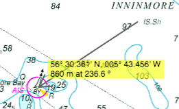
Clicking and dragging while holding down the Shift key will draw a temporary bearing line on the chart, displaying distance and angle.
A control panel overlays the top right of the displayed chart, and gives additional information including depth (DPT) and speed over the ground (SOG), and contains control buttons as described here. To maximise the screen space available for displaying a chart, the visibility of the control panel can be toggled by clicking this icon  at the top right of the window.
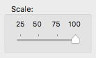
The scale control is a slider with 4 positions allowing the user to change the zoom percentage of the displayed chart.
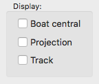
If the "Boat central" checkbox is ticked, the chart will be automatically scrolled so that the boat is kept in a central position.
If the "Projection" checkbox is ticked, then a line will be displayed indicating the projected position after a time interval set in AngelPilot preferences.
If the "Track" checkbox is ticked, then the stored track is also displayed.
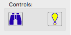
The button on the left scrolls the chart in order to display the boat, as long as there is a valid boat position available, and it is in the area covered by the chart.
The button on the right will insert a waypoint on the chart at the current boat position.